1.800.336.5437
Low Price GuaranteeTrack OrderWish ListEZ ReturnsMonday through Friday 7am to 7pm Saturday 8am to 4pm
- MOUNTAIN TIME
- ¡Hablamos español!


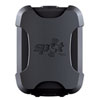
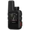
Garmin Montana 680 GPS

Garmin Montana 680 GPS
161678People who have viewed this item have also viewedSee all GPS/Navigation
Details
One of Garmin’s flagship GPS models that’s near the top of their handheld lineup, the Montana 680 GPS sports exceptional navigation capability along with a premium touch screen and a form factor that’s ideal for holding in your hand and mounting to a motorcycle, UTV, or ATV.Garmin makes the Montana 680 so effective by giving it all the key features you’d expect—including precise navigation, good battery life, and waypoint logging—and combining them with additional features that make the Montana 680 a premium option. A 4-inch color touchscreen provides easy navigation through the unit’s menus and clear orientation when you’re viewing maps. This display also supports dual orientation and several mapping options—including topography, water, and city mapping—that together give the unit outstanding versatility.
Other key features include an 8 megapixel camera, a 3-axis tilt-compensated compass, a microSD slot for expandable memory/maps, and a one-year BirdsEye Satellite Imagery subscription for directly downloading detailed aerial imagery. All these features are put into a rugged enclosure that’s IPX7 water rated, making the Montana 680 one of the best GPS units for trips that take you through harsh conditions.
Specifications
- Physical dimensions: 2.9" x 5.7" x 1.4" (7.48 x 14.42 x 3.64 cm)
- Weight: 10.2 oz (289 g) with included lithium-ion battery pack; 11.7 oz (333 g) with 3 AA batteries (not included)
- Battery: rechargeable lithium-ion (included) or 3 AA batteries (not included); NiMH or Lithium recommended
- Display type: Touchscreen, bright, transflective 65k color TFT, dual-orientation touchscreen; sunlight readable
- Display size: 2"W x 3.5"H (5.06 x 8.93 cm); 4" diag (10.2 cm)
- Display resolution: 272 x 480 pixels
- Battery life: up to 16 hours (lithium-ion); up to 22 hours (AA batteries)
- Memory/History: 4 GB
- Interface: high-speed USB and NMEA 0183 compatible
- High-sensitivity receiver
- IPX7: Suitable for
-Mounting on vehicles (e.g. boat, motorcycle, bike, ATV, golf cart)
-Splashes
-Rain or snow
-Incidental exposure to water of up to 1 meter for up to 30 minutes
Maps & Memory - Storage and Power Capacity: microSD™ card (not included)
- Waypoints/favorites/locations: 4000
- Routes: 200
- Track log: 10,000 points, 200 saved tracks
- Ability to add maps
- Basemap
- 1-year BirdsEye Satellite Imagery subscription
- Supports BirdsEye satellite imagery, Garmin Custom Maps and photo navigation
- Uses map data to display your "full track view"
- Logs everything (waypoints, tracks, caches, etc.) on your calendar for review
- Shares waypoints, tracks, routes and geocaches wirelessly with other compatible GPS units
Sensors & Interface - Barometric altimeter
- Tilt-compensated 3-axis compass
- Includes a QWERTY keyboard so you can find what you need and take notes faster.
- Changes to "night mode" automatically so your eyes stay focused
- Includes a microSD™ card slot so you can load external maps
Outdoor Recreation Features - Area calculation
- Automatic routing (turn by turn routing on roads)
- Paperless Geocaching-friendly
- Custom maps compatible
- Hunt/fish calendar
- Sun and moon information
- 8 megapixel Camera with autofocus; automatic geo-tagging
- Picture viewer
- Garmin Connect™ compatible (online community where you analyze, categorize and share data)
- Screen locks to keep it from shifting directions (portrait to landscape or vice versa)
- Maintains position tracking even in heavy cover and deep canyons
Garmin Montana 680 GPS Reviews
 Each review submitted enters you into a
$100 gift card monthly drawing and a
$500 gift card quarterly drawing!
Each question or answer submitted enters you into a:$100 gift card monthly drawing and a
$500 gift card quarterly drawing!